Visit Tijuana Baja California Mexico with FlexiTours
HOME
Run of the World HomePage
FlexiTours HomePage
SITE NAVIGATOR
Maps & Neighborhoods of
Tijuana, Baja California, M
exico
video soon

The municipality of Tijuana is divided into administrative boroughs (delegaciones, in Spanish) of which the city of Tijuana occupies nine, which are in turn divided into colonias. These boroughs offer administrative services such as urban planning, civil registry, inspection, verification, public works and community development and are served by a delegado. ...

View Larger Map

The boroughs are:

  • Centenario — This is the borough with the largest number of factories and maquiladoras. Its largest colony is Ciudad Industrial ("Industrial City"). Three of the city's most important streets, Boulevard Bellas Artes, Boulevard Industrial and Tijuana-Tecate Highway, are located here.
  • Centro — This is the historical midpoint of Tijuana; the municipal palace is located here as well as most of the tourist zones, such as Avenida Revolución and the business district. The Tijuana Cultural Center (CECUT for CEntro CUltural de Tijuana) is located here as well as the Plaza Río Tijuana, until recently the largest mall in the state.
  • Cerro Colorado — The Cerro Colorado ("Red Hill") is located here and it is surrounded by houses. Because of its height many of the area's antennae for radio and television stations are located on its peak.
  • La Mesa — This is the where the Morelos Park, the largest public park in the city, is located, as well as the Plaza Mundo Divertido, the new Macroplaza and the CETYS University.
  • Mesa de Otay — In this borough sits the Tijuana International Airport as well as the Otay Mesa entry to the United States. The Tijuana campus of the Autonomous University of Baja California and the Friendship Park are also located here as well as many maquiladoras.
  • Playas de Tijuana — This is the westernmost borough of the city bordered by the Pacific Ocean on the west and the United States border on the north. This is where the beaches of Tijuana are located (hence the name) and it is also one of the two exits to the south towards Rosarito and Ensenada.
  • La Presa — This is the largest borough in size and the Abelardo L. Rodriguez Dam is located within its limits, hence its name ("Presa" translates as "Dam" in English). The new Corredor Tijuana 2000 s and the Tijuana-Tecate free road run through it.
  • San Antonio de los Buenos — This is mostly a residential area although it also has two industrial parks.
  • Sanchez Taboada — Like the previous borough this is mostly a residential area
  • Rosarito was a delegation of Tijuana until it became its own municipality in 1995


to advertise your business on 'Run of the World's' website CLICK HERE
this page is sponsored by...

The Neighborhoods of Tijuana - MAPS-NEIGHBORHOODS
Tijuana can be divided into a number of neighboorhoods or 'Barrios'or 'Colonias' such as Colonia Libertad. These neighborhoods stretch from downtown to Zona Rio, east out into the hillsides of Tijuana, or west into the canyon neighborhoods leading to 'las Playas', or the beaches of Tijuana.

Within the Municipality of Tijuana, there are nine delegaciones, or administrative districts:
1. Playas de Tijuana, 2. Centro, 3. San Antonio, 4. Mesa de Otay, 5. La Mesa, 6. Sánchez Taboada, 7. Centenario, 8. Cerro Colorado, 9. La PresaMAPS OF TIJUANA- GOOGLE - 'Ave. Revolucion' by Google - Tijuana Convention & Visitors - www.advantagemexico.com
CENTRO-
'Centro' Tijuana is where the famous 'Revolution Avenue' or 'Avenida Revolucion' is located.
ZONA RIO- 'Zona Rio' or the River, is where modern Tijuana can be found with top restaurants and shopping.
LINKS- Wiki
COLONIA LIBERTAD - Map
News -
AGUA CALIENTE-
'Agua Caliente' is where you can find Greyhound racing and gambling action, along with golfing.
PUEBLO AMIGO-
This Plaza has a number of hotels, restaurants and nightclubs.
PLAZA FIESTA-
This area near Zona Rio can offer a variety of restaurants and clubs. Near the Cultural Center on Paseo de los Heroes. LINK
OTAY-
This area of Tijuana is east of downtown and uphill and near the Tijuana International Airport.
From San Diego Freeways '5' or '805' South you can take Highway '905' to this border crossing.
LA MESA- Main bus station.
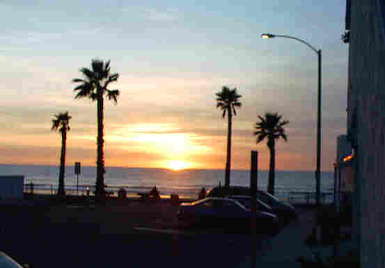
'LAS PLAYAS' DE TIJUANA-
To the west of downtown Tijuana, over the hills and out to the ocean is the quiet border community of 'Las Playas de Tijuana', or 'the beaches of Tijuana'. Here you can find the 'Bullring by the Sea' where you can watch a bullfight from May to October. You can also have fish tacos from a small family cafe, or just sit and watch the ocean sunset while sipping a Mexican beer from the local bar on the beach, or enjoy a Mexican hot chocolate from a beachside coffee house!... for more info


TIJUANA TRAVEL GUIDE WEBSITES & LINKS
You will find here links for a number of websites regarding Tijuana,
and a few travel writers for Tijuana and Baja Mexico.
Paula McDonald


LINKS-
TIJUANA ATTRACTIONS LINKS
You will find here links for a number of websites regarding Tijuana attractions,
Tijuana Tourism Tijuana Convention-Visitors

TripAdvisor.com

www.advantagemexico.com
LINKS TO TO OTHER TIJUANA MEXICO PAGES ON THIS SITE-
LINKS TO TO OTHER BAJA MEXICO PAGES ON THIS SITE-
MEXICO
MEXICO INFO
TIJUANA
ROSARITO
ENSENADA
TECATE
TECATE TOURS
NORTH BAJA WINE
NORTH BAJA LOOP
NORTH BAJA COAST


CLICK ON THE SECTION ICON OR USE THE DROP DOWN MENU AND SELECT THE PAGE YOU WANT TO SEE!
<-CLICK ON THE GLOBE TO GO TO THE HOMEPAGE, CLICK THE COMPASS FOR THE SITE DIRECTORY->,
SEARCH THE ENTIRE SITE WITH GOOGLE, OR CHOOSE FROM THE DROPDOWN MENUS ABOVE.

HOME
HOMEPAGE
Google
SITE NAVIGATOR
NAVIGATE

you are visitor

thanks for stopping by!

page added to site 2006, this webpage last updated on... 30 May, 2013

If you have any comments, questions or requests for information to be seen on this page please contact
webmaster@runoftheworld.com